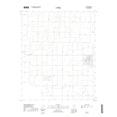
2019 Map of Olton
USGS Topo · Published 2019About this map
The high plains of Lamb County define this landscape, where the town of Olton serves as a concentrated center of activity amidst a vast, rectangular grid of agricultural roads. Located in the southeastern portion of the quadrangle, the community is organized around a traditional street plan, including numbered thoroughfares like 1st St and 5th St. To the west, the small settlement of Circle marks a junction on the highway. The surrounding terrain is characterized by numerous small, ephemeral basins and depressions typical of the Llano Estacado. This network of farm-to-market roads, such as Fm 168 and Fm 1072, facilitates the transit of agricultural goods throughout the region. The map captures the persistence of the rural Texas grid, where county roads like Co Rd 82 and Co Rd 122 stretch for miles across the level topography, connecting isolated farmsteads to the regional hubs.
Find a feature on this map
58 named features on this map. Tap any name to fly to it.
Don’t see what you’re looking for? This feature index may not catch every label — zoom into the map to look around manually.
Map Details
Editions of this 2019 Olton Map
This is the sole edition of this map. No revisions or reprints were ever made.
Other maps of this area

1954 · Clovis
USGS Topo · 1:250,000

1958 · Clovis
USGS Topo · 1:250,000

1962 · Cofferville
USGS Topo · 1:24,000

1962 · Springlake
USGS Topo · 1:24,000

1962 · Fieldton
USGS Topo · 1:24,000

1963 · Olton
USGS Topo · 1:24,000

1963 · Dodd SE
USGS Topo · 1:24,000

1963 · Hart SW
USGS Topo · 1:24,000

1965 · Hilburn
USGS Topo · 1:24,000
1968 · Corry
USGS Topo · 1:24,000