1937 Map of Olympia
USGS Topo · Published 1943About this map
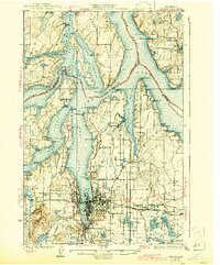
The southern reaches of Puget Sound converge at Olympia, where the state capital is shown just before the mid-century expansion of its suburban and industrial footprint. This 1930s survey captures the region's complex shoreline, defined by fingers of water like Budd Inlet and Eld Inlet, and the intricate network of islands and passages including Squaxon Island Reservation and Pickering Passage. The landscape is a mix of maritime activity and early inland development, with the Northern Pacific and Union Pacific railroads linking the waterfront to timber and milling centers like Union Mills.
Find a feature on this map
116 named features on this map. Tap any name to fly to it.
Don’t see what you’re looking for? This feature index may not catch every label — zoom into the map to look around manually.
Map Details
Editions of this 1937 Olympia Map
2 editions found
Other maps of this area

1916 · Chehalis
USGS Topo · 1:125,000

1937 · Olympia
USGS Topo · 1:62,500

1938 · Allyn
USGS Topo · 1:62,500

1939 · Shelton
USGS Topo · 1:62,500

1940 · Tenino
USGS Topo · 1:62,500

1940 · Anderson Island
USGS Topo · 1:62,500

1941 · Gate
USGS Topo · 1:62,500

1942 · Gig Harbor
USGS Topo · 1:62,500

1943 · Potlatch
USGS Topo · 1:62,500

1943 · Gig Harbor
USGS Topo · 1:62,500