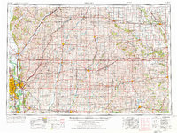
1954 Map of Omaha
USGS Topo · Published 1976About this map
The Missouri River corridor serves as the anchor for this mid-century look at the eastern edge of the Great Plains, where the bustling urban centers of Omaha and Council Bluffs define the river crossing. The 1974 revision of this 1954 data reveals a landscape shaped by both military presence at Offutt Air Force Base and social institutions like the School for the Deaf. To the east, the terrain transitions into a grid of agricultural towns connected by a dense rail network, including the Chicago and North Western and Union Pacific lines.
Find a feature on this map
326 named features on this map. Tap any name to fly to it.
Don’t see what you’re looking for? This feature index may not catch every label — zoom into the map to look around manually.
Map Details
Editions of this 1954 Omaha Map
3 editions found

Other maps of this area

1893 · Omaha
USGS Topo · 1:62,500

1893 · Fremont
USGS Topo · 1:125,000

1896 · Fremont
USGS Topo · 1:125,000

1903 · Weeping Water
USGS Topo · 1:125,000

1908 · Waukee
USGS Topo · 1:62,500

1911 · Madrid
USGS Topo · 1:62,500

1914 · Madrid
USGS Topo · 1:62,500

1916 · Boone
USGS Topo · 1:62,500

1929 · Weeping Water
USGS Topo · 1:125,000

1935 · Nehawka
USGS Topo · 1:48,000