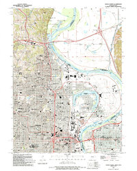
1994 Map of Omaha North
USGS Topo · Published 1995About this map
Omaha and its historic northern neighborhoods dominate this mid-1990s landscape, illustrating the city's complex urban development along the western banks of the Missouri River. The area around the historic Florence district is clearly detailed, showing the relationship between the river's Florence Bend and major transportation corridors like the Mormon Bridge. The map captures a dense concentration of civic and spiritual institutions, from the towering St Cecilia Cathedral and the sprawling Creighton University campus to the medical complex of the Univ of Nebraska Medical Center. Across the water, the industrial and aviation hub of Eppley Airfield sits within the river's loops, while Council Bluffs appears on the eastern shore. Genealogists and local historians will find significant value in the detailed plotting of major burial grounds, including the expansive Forest Lawn Cemetery, Prospect Hill Cem, and Holy Sepulchre Cem.
Find a feature on this map
46 named features on this map. Tap any name to fly to it.
Don’t see what you’re looking for? This feature index may not catch every label — zoom into the map to look around manually.
Map Details
Editions of this 1994 Omaha North Map
This is the sole edition of this map. No revisions or reprints were ever made.
Other maps of this area

1893 · Omaha
USGS Topo · 1:62,500

1893 · Fremont
USGS Topo · 1:125,000

1896 · Fremont
USGS Topo · 1:125,000

1954 · Omaha
USGS Topo · 1:250,000

1955 · Fremont
USGS Topo · 1:250,000

1956 · Ralston
USGS Topo · 1:24,000

1956 · Irvington
USGS Topo · 1:24,000

1956 · Council Bluffs North
USGS Topo · 1:24,000

1956 · Omaha North
USGS Topo · 1:24,000

1956 · Council Bluffs South
USGS Topo · 1:24,000