
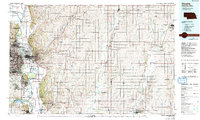
1985 Map of Omaha
USGS Topo · Published 1985About this map
Offutt Air Force Base and the expansive rail network of the Union Pacific and Burlington Northern dominate the landscape of the Missouri River valley during the mid-1980s. This survey captures the urban density of Omaha and Council Bluffs as they face one another across the river, showing the intricate highway system including I-29 and I-80 that binds the two states. Beyond the city centers, the map details the transition into the agricultural heartland of eastern Nebraska and western Iowa, where smaller settlements like Minden, Treynor, and Glenwood are connected by a web of creeks and rivers.
Find a feature on this map
138 named features on this map. Tap any name to fly to it.
Don’t see what you’re looking for? This feature index may not catch every label — zoom into the map to look around manually.
Map Details
Editions of this 1985 Omaha Map
2 editions found
Other maps of this area

1893 · Omaha
USGS Topo · 1:62,500

1893 · Fremont
USGS Topo · 1:125,000

1896 · Fremont
USGS Topo · 1:125,000

1903 · Weeping Water
USGS Topo · 1:125,000

1929 · Weeping Water
USGS Topo · 1:125,000
1935 · Nehawka
USGS Topo · 1:48,000
1940 · Nehawka
USGS Topo · 1:62,500

1954 · Omaha
USGS Topo · 1:250,000

1955 · Fremont
USGS Topo · 1:250,000

1955 · Nebraska City
USGS Topo · 1:250,000