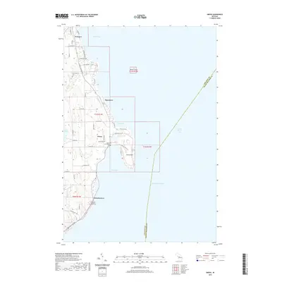
2019 Map of Omena
USGS Topo · Published 2019About this map
Omena and the surrounding Leelanau Peninsula shoreline are documented here as they appeared in 2019. The map details a landscape defined by its relationship with Lake Michigan, featuring prominent coastal landmarks like Omena Point and Bellow Island in the middle of Grand Traverse Bay. The settlement patterns show established clusters at Northport, Ahgosatown, and the tribal community of Peshawbestown. Genealogists will find several burial grounds noted, including Omena Cem, the Omena Presbyterian Cem, and the Immaculate Conception Catholic Cem near the southern boundary. The interior is a network of local roads such as Ingalls Bay Rd and N West Bay Shore Dr, weaving around freshwater bodies like Mougeys Lake and Bass Lake. These features reveal a coastal region balancing its agricultural heritage with its identity as a lakeside retreat.
Find a feature on this map
53 named features on this map. Tap any name to fly to it.
Don’t see what you’re looking for? This feature index may not catch every label — zoom into the map to look around manually.
Map Details
Editions of this 2019 Omena Map
This is the sole edition of this map. No revisions or reprints were ever made.
Other maps of this area

1954 · Central Lake
USGS Topo · 1:62,500

1954 · Traverse City
USGS Topo · 1:250,000

1955 · Cheboygan
USGS Topo · 1:250,000

1957 · Traverse City
USGS Topo · 1:62,500

1957 · Northport
USGS Topo · 1:62,500

1957 · Elk Rapids
USGS Topo · 1:62,500

1958 · Cheboygan
USGS Topo · 1:250,000

1958 · Traverse City
USGS Topo · 1:250,000

1983 · Northport
USGS Topo · 1:25,000

1983 · Omena
USGS Topo · 1:24,000