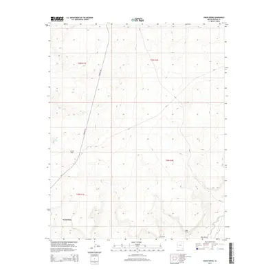
2014 Map of Onion Spring
USGS Topo · Published 2014About this map
Second Mesa rises above the surrounding plateau in this high-desert landscape of Navajo County, which was surveyed here in the early 21st century. The terrain is defined by dramatic escarpments like Coal Point and Meat Point, which overlook the lower elevations of the Wepo Valley. Water sources, critical to the history of this arid region, are marked by isolated points such as Onion Spring and Goat Spring. Connectivity across this high ground is maintained by the Turquoise Trl and routes designated as BIA-4 and BIA-8, reflecting the modern infrastructure managed within tribal lands. Drainage patterns are visible along the course of Wepo Wash, illustrating the seasonal movement of water through the valley floors that carve between the mesas.
Find a feature on this map
16 named features on this map. Tap any name to fly to it.
Don’t see what you’re looking for? This feature index may not catch every label — zoom into the map to look around manually.
Map Details
Editions of this 2014 Onion Spring Map
This is the sole edition of this map. No revisions or reprints were ever made.
Other maps of this area

1883 · Marsh Pass
USGS Topo · 1:250,000
1883 · Tusayan
USGS Topo · 1:250,000
1886 · Tusayan
USGS Topo · 1:250,000

1892 · Marsh Pass
USGS Topo · 1:250,000

1947 · Flagstaff
USGS Topo · 1:250,000
1954 · Flagstaff
USGS Topo · 1:250,000

1956 · Marble Canyon
USGS Topo · 1:250,000
1958 · Flagstaff
USGS Topo · 1:250,000

1959 · Marble Canyon
USGS Topo · 1:250,000
1960 · Flagstaff
USGS Topo · 1:250,000