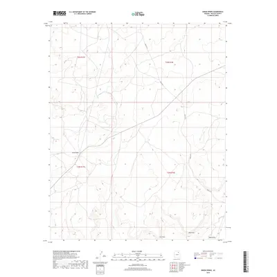
2018 Map of Onion Spring
USGS Topo · Published 2018About this map
Second Mesa serves as a primary geographic anchor in this Navajo County landscape, where traditional land use and desert topography define the character of the region. The map documents a sparse but vital network of water sources, including Onion Spring in the north and Goat Spring further south, which are essential landmarks in this arid environment. The presence of Indian Rte 8 provides the primary transit corridor, cutting diagonally across the high plateau and connecting the various ridges and drainages. Terrain features such as Coal Point and Meat Point rise above the southern reaches, overlooking the Wepo Valley and the intermittent drainage of Wepo Wash. These labels reflect a deeply rooted cultural landscape where naming conventions often point to specific resources or significant local landmarks within the mesa country.
Find a feature on this map
12 named features on this map. Tap any name to fly to it.
Don’t see what you’re looking for? This feature index may not catch every label — zoom into the map to look around manually.
Map Details
Editions of this 2018 Onion Spring Map
This is the sole edition of this map. No revisions or reprints were ever made.
Other maps of this area

1883 · Marsh Pass
USGS Topo · 1:250,000
1883 · Tusayan
USGS Topo · 1:250,000
1886 · Tusayan
USGS Topo · 1:250,000

1892 · Marsh Pass
USGS Topo · 1:250,000

1947 · Flagstaff
USGS Topo · 1:250,000
1954 · Flagstaff
USGS Topo · 1:250,000

1956 · Marble Canyon
USGS Topo · 1:250,000
1958 · Flagstaff
USGS Topo · 1:250,000

1959 · Marble Canyon
USGS Topo · 1:250,000
1960 · Flagstaff
USGS Topo · 1:250,000