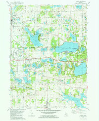
1980 Map of Onsted
USGS Topo · Published 1981About this map
The Irish Hills region of Michigan is defined by a high concentration of glacial kettle lakes and recreation sites as they appeared in 1980. This survey shows the established leisure landscape around Brooklyn, where the Michigan International Speedway and several large camps like Judson Collins Camp and Camp O' The Hills represent the area's mid-century tourism. Hayes State Park and Cambridge State Historic Park preserve significant tracts of the lakefront, while smaller settlements like Springville and Onsted anchor the southern portion of the sheet.
Find a feature on this map
87 named features on this map. Tap any name to fly to it.
Don’t see what you’re looking for? This feature index may not catch every label — zoom into the map to look around manually.
Map Details
Editions of this 1980 Onsted Map
2 editions found
Other maps of this area

1935 · Jackson
USGS Topo · 1:48,000

1939 · Jackson
USGS Topo · 1:62,500

1948 · Manchester
USGS Topo · 1:62,500

1949 · Manchester
USGS Topo · 1:62,500

1953 · Fort Wayne
USGS Topo · 1:250,000

1956 · Fort Wayne
USGS Topo · 1:250,000

1958 · Grand Rapids
USGS Topo · 1:250,000

1961 · Grand Rapids
USGS Topo · 1:250,000

1962 · Grand Rapids
USGS Topo · 1:250,000
1962 · Adrian
USGS Topo · 1:24,000