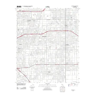
2012 Map of Ontario
USGS Topo · Published 2012About this map
Claremont, Montclair, and Upland are centered in this highly developed Inland Empire landscape, reflecting the suburban expansion and academic clusters of the early 21st century. The map highlights significant educational institutions such as Claremont Graduate University and the Western University of Health Sciences, alongside local landmarks like the Cable Airport and the Mission Tiki Drive-In Theatre. This era of the region’s growth is characterized by a dense grid of residential streets and arterial roads like W Arrow Hwy and San Bernardino Rd. A notable remnant of earlier land use is found at Voortman's Egg Ranch near the southern boundary, while the presence of the Metrolink rail line underscores the area's transition into a major commuter hub. Water management is visible through engineered features like the San Antonio Creek Channel and the Ontario Reservoir Number 1.
Find a feature on this map
116 named features on this map. Tap any name to fly to it.
Don’t see what you’re looking for? This feature index may not catch every label — zoom into the map to look around manually.
Map Details
Editions of this 2012 Ontario Map
This is the sole edition of this map. No revisions or reprints were ever made.
Other maps of this area

1894 · Pomona
USGS Topo · 1:62,500

1896 · Anaheim
USGS Topo · 1:62,500

1897 · Pomona
USGS Topo · 1:62,500

1897 · Cucamonga
USGS Topo · 1:62,500

1898 · Pomona
USGS Topo · 1:62,500

1898 · Anaheim
USGS Topo · 1:62,500

1900 · Cucamonga
USGS Topo · 1:62,500

1901 · Southern California Sheet No. 1
USGS Topo · 1:250,000

1901 · Anaheim
USGS Topo · 1:62,500

1902 · Corona
USGS Topo · 1:125,000