
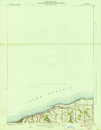
1942 Map of Ontario
USGS Topo · Published 1942About this map
Ontario and Walworth anchor this 1942 survey, which illustrates a landscape defined by an extensive grid of local roads and the prominent path of the New York Central Railroad. The presence of numerous numbered schoolhouses, such as School No 11 and School No 7, indicates a well-established rural education network serving the surrounding hamlets of Fruitland, Ontario Center, and Union Hill. The terrain is characterized by several distinct rises including Nigger Hill, Mathewson Hill, and Drummonds Hill, while the drainage is managed by a series of north-flowing watercourses like Fourmile Creek and Mill Creek. Local genealogy and land use are reflected in cemetery locations such as Dixon Cem and Calvary Cem, as well as the naming of rural routes like Ore Bed Road, which hints at the area's geological and industrial history.
Find a feature on this map
84 named features on this map. Tap any name to fly to it.
Don’t see what you’re looking for? This feature index may not catch every label — zoom into the map to look around manually.
Map Details
Editions of this 1942 Ontario Map
This is the sole edition of this map. No revisions or reprints were ever made.
Other maps of this area

1899 · Palmyra
USGS Topo · 1:62,500

1900 · Macedon
USGS Topo · 1:62,500

1902 · Pultneyville
USGS Topo · 1:62,500

1902 · Palmyra
USGS Topo · 1:62,500

1932 · Webster
USGS Topo · 1:24,000

1932 · Fairport
USGS Topo · 1:24,000

1934 · Fairport
USGS Topo · 1:24,000
1934 · Ninemile Point
USGS Topo · 1:24,000

1934 · Webster
USGS Topo · 1:24,000

1942 · Pultneyville
USGS Topo · 1:31,680