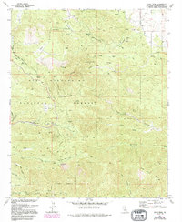
1972 Map of Onyx Peak
USGS Topo · Published 1994About this map
Onyx Peak stands as the dominant topographical feature in this high-altitude landscape within the San Bernardino National Forest. The map reflects a region of sparse settlement but significant activity, characterized by high-mountain springs and small-scale mining operations like the Rose Mine and Onyx Mine. The complex network of canyons, including Old Timer Canyon and Pipes Canyon, reveals how geography dictated movement through the territory.
Find a feature on this map
36 named features on this map. Tap any name to fly to it.
Don’t see what you’re looking for? This feature index may not catch every label — zoom into the map to look around manually.
Map Details
Editions of this 1972 Onyx Peak Map
3 editions found
Other maps of this area

1901 · Southern California Sheet No. 1
USGS Topo · 1:250,000

1902 · San Gorgonio
USGS Topo · 1:125,000

1904 · Southern California Sheet No. 1
USGS Topo · 1:250,000

1947 · Lucerne Valley
USGS Topo · 1:62,500

1949 · Lucerne Valley
USGS Topo · 1:62,500

1953 · San Bernardino
USGS Topo · 1:250,000

1954 · San Gorgonio Mountain
USGS Topo · 1:62,500

1955 · Old Woman Springs
USGS Topo · 1:62,500

1955 · Morongo Valley
USGS Topo · 1:62,500

1956 · San Bernardino
USGS Topo · 1:250,000