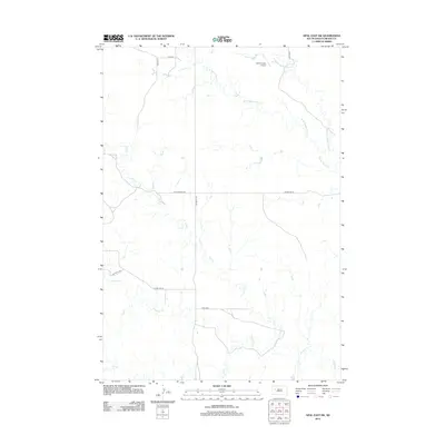
2012 Map of Opal East SW
USGS Topo · Published 2012About this map
Sulphur Crk and its various tributaries define this section of the western South Dakota plains. The landscape is marked by a systematic grid of section lines and rural routes, including Fox Ridge Rd, Rattlesnake Rd, and Trail End. This area of Meade County is characterized by significant watercourses that drain the prairie, most notably the branches of Beaver Dam Cr, including W Br Beaver Dam Cr and Middle Br Beaver Dam Cr. The presence of the Vig Limousin Airport in the northern portion of the quadrangle suggests the specialized ranching operations common to this region. Other notable waterways include Pine Cr and Elm Cr, which weave between the local highway and gravel roads like Co Hwy MC-30.
Find a feature on this map
15 named features on this map. Tap any name to fly to it.
Don’t see what you’re looking for? This feature index may not catch every label — zoom into the map to look around manually.
Map Details
Editions of this 2012 Opal East SW Map
This is the sole edition of this map. No revisions or reprints were ever made.
Other maps of this area

1953 · Rapid City
USGS Topo · 1:250,000

1957 · Rapid City
USGS Topo · 1:250,000

1959 · Redowl
USGS Topo · 1:24,000

1983 · Whiteman Owl NW
USGS Topo · 1:24,000

1983 · Opal West SE
USGS Topo · 1:24,000

1983 · Lemmon Butte
USGS Topo · 1:24,000
1983 · Opal East
USGS Topo · 1:24,000

1983 · Opal East SW
USGS Topo · 1:24,000

1983 · Marcus
USGS Topo · 1:24,000
1983 · Opal East SE
USGS Topo · 1:24,000