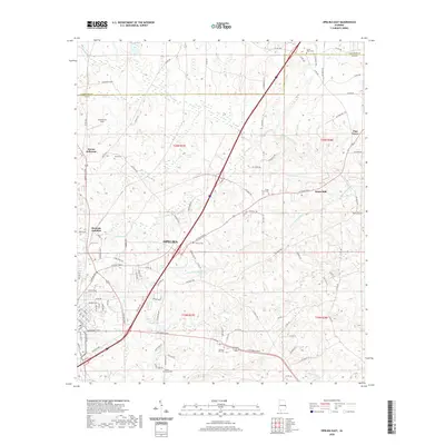
2020 Map of Opelika East
USGS Topo · Published 2020About this map
Opelika serves as the central hub of this East Alabama landscape, where the convergence of modern transportation routes meets a deep-seated rural history. The landscape is defined by the headwaters and tributaries of Halawakee Creek, including Little Halawakee Creek and Wacoochee Creek, which carved the drainage patterns long before the modern expansion of Sommerset Strip and Mount Jefferson.
Find a feature on this map
98 named features on this map. Tap any name to fly to it.
Don’t see what you’re looking for? This feature index may not catch every label — zoom into the map to look around manually.
Map Details
Editions of this 2020 Opelika East Map
This is the sole edition of this map. No revisions or reprints were ever made.
Other maps of this area

1907 · Opelika
USGS Topo · 1:125,000

1909 · Opelika
USGS Topo · 1:125,000

1955 · Phenix City
USGS Topo · 1:250,000

1957 · Phenix City
USGS Topo · 1:250,000

1958 · Phenix City
USGS Topo · 1:250,000

1964 · Lanett South
USGS Topo · 1:24,000
1965 · Bleecker
USGS Topo · 1:24,000
1965 · Beulah
USGS Topo · 1:24,000

1970 · Opelika East
USGS Topo · 1:24,000

1971 · Parkers Crossroads
USGS Topo · 1:24,000