1907 Map of Opelika
USGS Topo · Published 1963About this map
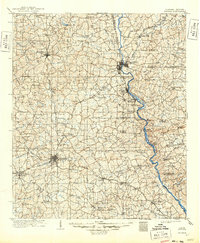
The railroad junction of Opelika and the industrial activity along the Chattahoochee River define the landscape of eastern Alabama and western Georgia in the early twentieth century. This survey documents the critical transportation corridors that fueled the region's development, including the Central of Georgia and the Western Railway of Alabama. Along the river, a series of important crossings such as Houston Ferry, Blanton Ferry, and Dixon Ferry provided essential links between Alabama and Georgia before the widespread construction of highway bridges.
Find a feature on this map
119 named features on this map. Tap any name to fly to it.
Don’t see what you’re looking for? This feature index may not catch every label — zoom into the map to look around manually.
Map Details
Editions of this 1907 Opelika Map
This is the sole edition of this map. No revisions or reprints were ever made.