
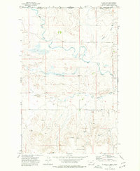
1973 Map of Opheim
USGS Topo · Published 1976About this map
Opheim sits at a geographic crossroads in northern Valley County, where the plains are etched by the winding drainages of Bog Coulee and Snow Coulee. This 1970s landscape is defined by its role as a strategic and logistical hub, most notably housing the Opheim Air Force Station west of the town center. The presence of the Burlington Northern railroad line and a local Airport underscores the importance of transportation in this remote agricultural region.
Find a feature on this map
15 named features on this map. Tap any name to fly to it.
Don’t see what you’re looking for? This feature index may not catch every label — zoom into the map to look around manually.
Map Details
Editions of this 1973 Opheim Map
This is the sole edition of this map. No revisions or reprints were ever made.
Other maps of this area

1919 · Boundary
USGS Topo · 1:125,000

1954 · Glasgow
USGS Topo · 1:250,000

1957 · Glasgow
USGS Topo · 1:250,000

1958 · Glasgow
USGS Topo · 1:250,000

1973 · Glentana West
USGS Topo · 1:24,000

1973 · Baylor NE
USGS Topo · 1:24,000

1973 · Baylor
USGS Topo · 1:24,000

1973 · Roanwood
USGS Topo · 1:24,000
1973 · Glass Hill
USGS Topo · 1:24,000

1984 · O'Juel Lake
USGS Topo · 1:24,000