1993 Map of Ophir
USGS Topo · Published 1993About this map
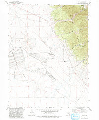
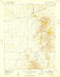
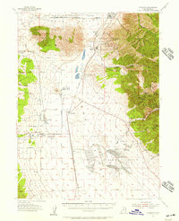
Ophir stands as a testament to the mining legacy of the Oquirrh Mountains, where the landscape is etched with the footprints of extraction. This survey illustrates a complex industrial topography, from the Mines and Tailings surrounding the settlement to the numerous Prospects and Quarry sites scattered across Lion Hill and Dry Mountain. The transition from the high-altitude mining district into the broad expanse of Rush Valley is punctuated by the massive footprint of the Tooele Army Depot (South Area), which occupies a significant portion of the southwestern quadrant. Between the rugged canyons like Silverado Canyon and the valley floor, the map traces the intersection of federal military utility and historical mineral wealth, visible in features like the Rifle Range and the old Cemetery near the townsite.
Find a feature on this map
32 named features on this map. Tap any name to fly to it.
Don’t see what you’re looking for? This feature index may not catch every label — zoom into the map to look around manually.
Map Details
Editions of this 1993 Ophir Map
This is the sole edition of this map. No revisions or reprints were ever made.
Other maps of this area

1885 · Tooele Valley
USGS Topo · 1:250,000

1915 · Fairfield
USGS Topo · 1:62,500

1917 · Fairfield
USGS Topo · 1:62,500

1918 · Stockton
USGS Topo · 1:62,500

1947 · Fivemile Pass
USGS Topo · 1:62,500
1949 · Fivemile Pass
USGS Topo · 1:24,000

1953 · Tooele
USGS Topo · 1:250,000
1955 · Stockton
USGS Topo · 1:62,500

1955 · Tooele
USGS Topo · 1:250,000

1968 · Mercur
USGS Topo · 1:24,000