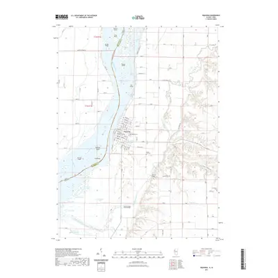
2021 Map of Oquawka
USGS Topo · Published 2021About this map
Oquawka sits at a strategic bend in the Mississippi River, where the landscape is defined by an intricate network of secondary waterways and islands. The presence of the Henderson County Courthouse and the nearby Oquawka Wagon Covered Bridge highlights the area's role as a civic and transportation hub for the surrounding river bottoms. Beyond the village limits, the terrain is fragmented by the Mississippi River into a series of landforms including Benton Island, Johnson Island, and Mill Island. To the south, a complex system of sloughs and backwaters like Prairie Slough and Phelps Slough indicates a dynamic floodplain environment. The map also documents the transition from these lowlands to higher ground, marked by features such as Jinks Hollow and the Davenport Bridge crossing over Henderson Creek. Local history is well-preserved through several burial sites, including Oquawka Cem, County Farm Cem, and Cumberland Cem.
Find a feature on this map
55 named features on this map. Tap any name to fly to it.
Don’t see what you’re looking for? This feature index may not catch every label — zoom into the map to look around manually.
Map Details
Editions of this 2021 Oquawka Map
This is the sole edition of this map. No revisions or reprints were ever made.
Other maps of this area

1934 · Oquawka
USGS Topo · 1:48,000

1934 · Burlington
USGS Topo · 1:48,000

1935 · Keithsburg
USGS Topo · 1:48,000

1940 · Oquawka
USGS Topo · 1:62,500

1940 · Burlington
USGS Topo · 1:62,500

1941 · Keithsburg
USGS Topo · 1:62,500

1946 · Wapello
USGS Topo · 1:62,500

1949 · Wapello
USGS Topo · 1:62,500

1958 · Burlington
USGS Topo · 1:250,000

1958 · Davenport
USGS Topo · 1:250,000