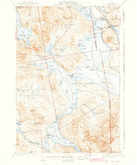
1942 Map of Oquossoc
USGS Topo · Published 1942About this map
Upper Richardson Lake and Lower Richardson Lake form the central axis of this wilderness survey, reflecting a landscape defined by water management and early recreation. The presence of Aziscohos Dam on the western edge at Aziscohos Lake and the water-level controls at Upper Dam and Middle Dam illustrate the industrial importance of the region's hydro-network during the early 1940s. These dams regulated flow through the Rapid River towards Umbagog Lake, supporting both timber interests and downstream power.
Find a feature on this map
88 named features on this map. Tap any name to fly to it.
Don’t see what you’re looking for? This feature index may not catch every label — zoom into the map to look around manually.
Map Details
Editions of this 1942 Oquossoc Map
3 editions found

Other maps of this area

1927 · Rumford
USGS Topo · 1:48,000

1927 · Second Lake
USGS Topo · 1:62,500

1930 · Rumford
USGS Topo · 1:62,500

1930 · Milan
USGS Topo · 1:62,500

1930 · Errol
USGS Topo · 1:62,500

1931 · Cupsuptic
USGS Topo · 1:48,000

1932 · Kennebago Lake
USGS Topo · 1:48,000

1932 · Second Lake
USGS Topo · 1:62,500

1933 · Rangeley
USGS Topo · 1:48,000

1933 · Milan
USGS Topo · 1:62,500