
1942 Map of Oquossoc
USGS Topo · Published 1942About this map
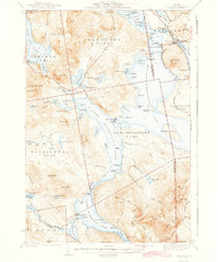
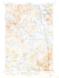
Mooselookmeguntic Lake and its intricate shoreline dominate this western Maine landscape, reflecting a region defined by its vast water resources and early 20th-century sporting culture. The settlement of Oquossoc serves as a northern hub, while the Oquossoc Angling Assn points to the area's long-standing draw for recreation. This 1940 survey documents a transition in local transportation, marking an Abandoned R. R. near Mountainview and the presence of the Appalachian Trail crossing through the southeastern peaks. The map reveals the infrastructure of the logging and power industries through the Aziscohos Dam and the strategically placed Upper Dam and Middle Dam. Isolated settlements like Farrington and seasonal camps are connected by a network of Old Roads and Farm Roads, while the surrounding terrain rises toward prominent heights such as Elephant Mtn and Old Blue Mtn.
Find a feature on this map
125 named features on this map. Tap any name to fly to it.
Don’t see what you’re looking for? This feature index may not catch every label — zoom into the map to look around manually.
Map Details
Editions of this 1942 Oquossoc Map
3 editions found
Other maps of this area

1927 · Rumford
USGS Topo · 1:48,000

1927 · Second Lake
USGS Topo · 1:62,500

1930 · Rumford
USGS Topo · 1:62,500

1930 · Milan
USGS Topo · 1:62,500

1930 · Errol
USGS Topo · 1:62,500

1931 · Cupsuptic
USGS Topo · 1:48,000

1932 · Kennebago Lake
USGS Topo · 1:48,000

1932 · Second Lake
USGS Topo · 1:62,500

1933 · Rangeley
USGS Topo · 1:48,000

1933 · Milan
USGS Topo · 1:62,500