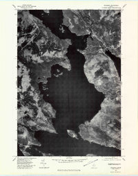
1977 Map of Oquossoc
USGS Topo · Published 1983About this map
Mooselookmeguntic Lake dominates this orthophotoquad, serving as the central basin for a complex network of waterways in Oxford County. Taken in late October 1977, the aerial photography reveals the stark interface between the deep water and the heavily wooded shoreline before the winter freeze. The settlement of Oquossoc sits at the northern narrows where the Kennebago River and Rangeley River converge, highlighting its role as a historical junction for river-and-lake travel. To the south, South Rangeley and the prominent Bald Mountain frame the eastern shore. The presence of Upper Dam at the western outlet toward Upper Richardson Lake underscores the importance of water management in this timber-rich region. This specific format of map, using rectified photography rather than traditional contours, provides a literal look at the forest density and the exact footprint of small settlements during the late 1970s.
Find a feature on this map
9 named features on this map. Tap any name to fly to it.
Don’t see what you’re looking for? This feature index may not catch every label — zoom into the map to look around manually.
Map Details
Editions of this 1977 Oquossoc Map
This is the sole edition of this map. No revisions or reprints were ever made.
Other maps of this area

1931 · Cupsuptic
USGS Topo · 1:48,000

1932 · Kennebago Lake
USGS Topo · 1:48,000

1933 · Rangeley
USGS Topo · 1:48,000

1934 · Cupsuptic
USGS Topo · 1:62,500

1935 · Kennebago Lake
USGS Topo · 1:62,500

1935 · Cupsuptic
USGS Topo · 1:62,500

1936 · Kennebago Lake
USGS Topo · 1:62,500

1939 · Rangeley
USGS Topo · 1:62,500

1940 · Oquossoc
USGS Topo · 1:62,500

1942 · Oquossoc
USGS Topo · 1:62,500
Featured Places
- Rangeley, ME
- Rangeley Plantation, ME
- Adamstown Township, ME
- Upper Dam, Richardsontown Township
- Pleasant Island, Adamstown Township