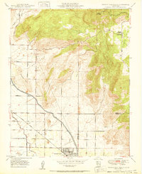
1950 Map of Orange Cove North
USGS Topo · Published 1950About this map
Orange Cove sits at the base of the Sierra foothills, serving as a hub for the citrus groves that dominate the flatlands of the San Joaquin Valley. This 1950 edition captures the irrigation infrastructure vital to the region's agricultural success, most notably the Friant Kern Canal which cuts diagonally across the landscape. The transition from the grid-aligned orchards along Citrus Ave and Central Ave to the uneven topography of Bear Mtn and Granite Hill illustrates the limits of early 20th-century cultivation.
Find a feature on this map
24 named features on this map. Tap any name to fly to it.
Don’t see what you’re looking for? This feature index may not catch every label — zoom into the map to look around manually.
Map Details
Editions of this 1950 Orange Cove North Map
This is the sole edition of this map. No revisions or reprints were ever made.
Other maps of this area

1920 · Orangedale School
USGS Topo · 1:24,000

1921 · Squaw Valley
USGS Topo · 1:31,680

1921 · Stokes Mountain
USGS Topo · 1:24,000

1922 · Trimmer
USGS Topo · 1:96,000

1923 · Sultana
USGS Topo · 1:31,680

1923 · Orangedale School
USGS Topo · 1:31,680

1923 · Wahtoke
USGS Topo · 1:31,680

1924 · Reedley
USGS Topo · 1:31,680

1924 · Citrus Cove
USGS Topo · 1:31,680

1924 · Dinuba
USGS Topo · 1:125,000