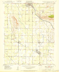
1950 Map of Orange Cove South
USGS Topo · Published 1950About this map
Agricultural development in the San Joaquin Valley is clearly defined here through a sophisticated network of irrigation and rail infrastructure at mid-century. The landscape is dominated by the Friant Kern Canal and the Alta Canal, which supported the citrus and grape-growing regions surrounding Orange Cove. The local economy is tied closely to the Atchison Topeka and Santa Fe and Southern Pacific railroads, which facilitated the movement of goods from small packing hubs and shipping points like Sultana, Orosi, and Cutler.
Find a feature on this map
31 named features on this map. Tap any name to fly to it.
Don’t see what you’re looking for? This feature index may not catch every label — zoom into the map to look around manually.
Map Details
Editions of this 1950 Orange Cove South Map
This is the sole edition of this map. No revisions or reprints were ever made.
Other maps of this area

1921 · Squaw Valley
USGS Topo · 1:31,680

1921 · Stokes Mountain
USGS Topo · 1:24,000

1922 · Trimmer
USGS Topo · 1:96,000

1923 · Sultana
USGS Topo · 1:31,680

1923 · Wahtoke
USGS Topo · 1:31,680

1924 · Reedley
USGS Topo · 1:31,680

1924 · Citrus Cove
USGS Topo · 1:31,680

1924 · Dinuba
USGS Topo · 1:125,000

1924 · Stokes Mountain
USGS Topo · 1:31,680

1926 · Ivanhoe
USGS Topo · 1:31,680