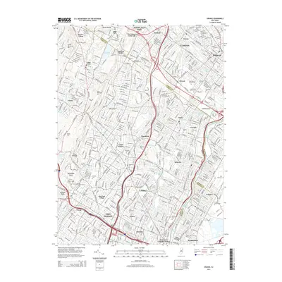
2014 Map of Orange
USGS Topo · Published 2014About this map
Llewellyn Park and the surrounding suburban corridors of Essex and Passaic counties are meticulously detailed in this 2014 survey. The map documents the dense residential and educational landscape of the early 21st century, anchored by institutions like Montclair State Univ and Bloomfield Coll. The urban fabric is punctuated by extensive green spaces and memorial sites, including Mt Hebron Cem and Crest Haven Memorial Park, reflecting the area's long-standing development.
Find a feature on this map
70 named features on this map. Tap any name to fly to it.
Don’t see what you’re looking for? This feature index may not catch every label — zoom into the map to look around manually.
Map Details
Editions of this 2014 Orange Map
This is the sole edition of this map. No revisions or reprints were ever made.
Other maps of this area

1888 · Plainfield
USGS Topo · 1:62,500

1888 · Morristown
USGS Topo · 1:62,500

1888 · Paterson
USGS Topo · 1:62,500

1892 · Paterson
USGS Topo · 1:62,500

1893 · Plainfield
USGS Topo · 1:62,500

1894 · Morristown
USGS Topo · 1:62,500
1898 · Morristown
USGS Topo · 1:62,500
1898 · Plainfield
USGS Topo · 1:62,500
1898 · Staten Island
USGS Topo · 1:62,500

1898 · Paterson
USGS Topo · 1:62,500