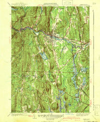
1941 Map of Orange
USGS Topo · Published 1941About this map
The Millers River corridor serves as the industrial and transit spine of this landscape, anchoring the bustling town of Orange and the smaller enclave of West Orange. The Boston and Maine Railroad follows the river's winding path, connecting the Wendell Depot to the manufacturing centers of the valley. To the south, the terrain transitions into the highlands of New Salem, where a series of ridges like North Pond Ridge and Bacon Hill define the rural character of the area.
Find a feature on this map
70 named features on this map. Tap any name to fly to it.
Don’t see what you’re looking for? This feature index may not catch every label — zoom into the map to look around manually.
Map Details
Editions of this 1941 Orange Map
3 editions found
Other maps of this area

1887 · Warwick
USGS Topo · 1:62,500

1887 · Belchertown
USGS Topo · 1:62,500

1887 · Winchendon
USGS Topo · 1:62,500

1887 · Barre
USGS Topo · 1:62,500

1889 · Barre
USGS Topo · 1:62,500

1889 · Warwick
USGS Topo · 1:62,500

1890 · Belchertown
USGS Topo · 1:62,500

1890 · Winchendon
USGS Topo · 1:62,500

1893 · Belchertown
USGS Topo · 1:62,500

1894 · Winchendon
USGS Topo · 1:62,500