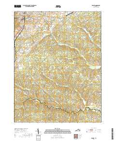
2019 Map of Orange
USGS Topo · Published 2019About this map
Orange serves as the focal point of this region, characterized by the Orange County Courthouse and a surrounding network of historical roads like W Main St and Harper Dr. The landscape transitions from the developed center of the county seat to a rural expanse defined by winding watercourses and small settlements. The southern portion of the quadrangle is bisected by the Orange and Louisa County line, where the N Anna River flows near Brooks Bridge.
Find a feature on this map
102 named features on this map. Tap any name to fly to it.
Don’t see what you’re looking for? This feature index may not catch every label — zoom into the map to look around manually.
Map Details
Editions of this 2019 Orange Map
This is the sole edition of this map. No revisions or reprints were ever made.
Other maps of this area

1887 · Spottsylvania
USGS Topo · 1:125,000

1892 · Spottsylvania
USGS Topo · 1:125,000

1892 · Gordonsville
USGS Topo · 1:125,000

1942 · Mineral
USGS Topo · 1:31,680

1942 · Lahore
USGS Topo · 1:31,680

1943 · Unionville
USGS Topo · 1:24,000
1944 · Unionville
USGS Topo · 1:31,680

1948 · Washington
USGS Topo · 1:250,000

1949 · Charlottesville
USGS Topo · 1:250,000

1956 · Charlottesville
USGS Topo · 1:250,000