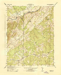
1944 Map of Unionville
USGS Topo · Published 1944About this map
Unionville and the surrounding Virginia countryside appear in sharp detail during the final years of World War II. The landscape is defined by the sharp meanders of the Rapidan River and the prominent rise of Clark Mountain, where the topography transitions from river bottomlands to ridges. Small rural hubs like Everona, Sleets Shop, and Grassland anchor the agricultural and social life of the area, while local history is marked by community centers such as Palmyra Church and Mt Pisgah Church.
Find a feature on this map
19 named features on this map. Tap any name to fly to it.
Don’t see what you’re looking for? This feature index may not catch every label — zoom into the map to look around manually.
Map Details
Editions of this 1944 Unionville Map
This is the sole edition of this map. No revisions or reprints were ever made.
Other maps of this area

1887 · Spottsylvania
USGS Topo · 1:125,000

1892 · Spottsylvania
USGS Topo · 1:125,000

1892 · Gordonsville
USGS Topo · 1:125,000

1942 · Lahore
USGS Topo · 1:31,680

1942 · Belmont
USGS Topo · 1:31,680

1943 · Germanna Bridge
USGS Topo · 1:24,000

1943 · Culpeper
USGS Topo · 1:24,000

1943 · Mine Run
USGS Topo · 1:24,000

1943 · Unionville
USGS Topo · 1:24,000
1944 · Culpeper
USGS Topo · 1:31,680