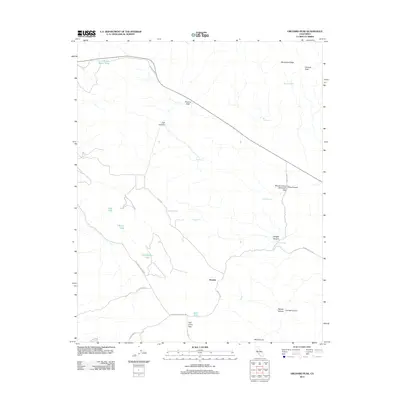
2012 Map of Orchard Peak
USGS Topo · Published 2012About this map
Annette stands as the central settlement in this high-altitude landscape where the Coast Ranges meet the desert interior. The terrain is defined by a series of significant crossings and summits, most notably Polonio Pass and Palo Prieto Pass, which have historically served as critical transit points through the hills. A complex network of ephemeral water sources and seasonal lakes, such as Twisselmann Lake, O'Brien Lake, and Still Lake, suggests a geography dependent on intermittent rainfall. Higher elevations are marked by distinctive landmarks including Orchard Peak and Bluestone Ridge, while numerous named springs like Railroad Spring and Indian Spring point to the vital locations where water could be found in an otherwise dry environment. The presence of McGovern Gap and several named canyons, including Jack Canyon and King Canyon, further illustrates the deep topographic relief that characterizes this part of Kern County.
Find a feature on this map
33 named features on this map. Tap any name to fly to it.
Don’t see what you’re looking for? This feature index may not catch every label — zoom into the map to look around manually.
Map Details
Editions of this 2012 Orchard Peak Map
This is the sole edition of this map. No revisions or reprints were ever made.
Other maps of this area

1914 · Cholame
USGS Topo · 1:125,000

1915 · Cholame
USGS Topo · 1:125,000

1917 · Cholame
USGS Topo · 1:125,000

1942 · Tent Hills
USGS Topo · 1:24,000

1943 · Packwood
USGS Topo · 1:31,680

1943 · Grant Lake
USGS Topo · 1:31,680

1943 · Commatti Canyon
USGS Topo · 1:31,680
1943 · Cholame
USGS Topo · 1:31,680
1943 · Tent Hills
USGS Topo · 1:31,680
1943 · Sawtooth Ridge
USGS Topo · 1:31,680