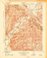
1943 Map of Cholame
USGS Topo · Published 1943About this map
Cholame and the surrounding ranching country of eastern San Luis Obispo County are captured here just as Fairchild Aerial Surveys compiled this topography for the War Department. The landscape is defined by its agricultural lineage, with numerous family-named homesteads and holdings such as Jack Ranch, Taylor Ranch, and Ludeke Ranch scattered across the Cholame Hills. At the crossroads, the Cholame School serves the local community near the confluence of White Canyon and Cholame Creek.
Find a feature on this map
45 named features on this map. Tap any name to fly to it.
Don’t see what you’re looking for? This feature index may not catch every label — zoom into the map to look around manually.
Map Details
Editions of this 1943 Cholame Map
This is the sole edition of this map. No revisions or reprints were ever made.
Other maps of this area

1914 · Cholame
USGS Topo · 1:125,000

1915 · Cholame
USGS Topo · 1:125,000

1917 · Cholame
USGS Topo · 1:125,000

1942 · Tent Hills
USGS Topo · 1:24,000

1943 · Grant Lake
USGS Topo · 1:31,680

1943 · Shandon
USGS Topo · 1:31,680

1943 · Commatti Canyon
USGS Topo · 1:31,680
1943 · Tent Hills
USGS Topo · 1:31,680

1943 · Shedd Canyon
USGS Topo · 1:31,680
1943 · Annette
USGS Topo · 1:31,680