
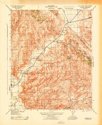
1943 Map of Commatti Canyon
USGS Topo · Published 1943About this map
The San Juan riverbed carves a wide path through the eastern San Luis Obispo County hills, defining a landscape of working ranches and secluded canyons during the early 1940s. Centered on Commatti Canyon, this topographic study reveals the dispersed settlement patterns of the era, where family-named holdings like Commatti Ranch, Alfalfa Ranch, and the E McCormack property anchored the local economy. The presence of the Alliance School near the junction of Tucker Canyon and Slocum Canyon indicates a established rural community even in this high-relief terrain. Survey markers from the U.S. Coast and Geodetic Survey, such as Cholame Tank and Red Hills, provide precise navigational anchors across the complex topography of McDonald Canyon and the Tin Can Canyon drainage, while locations like Sprague Camp and Alley Camp suggest seasonal or specialized land use in the backcountry.
Find a feature on this map
24 named features on this map. Tap any name to fly to it.
Don’t see what you’re looking for? This feature index may not catch every label — zoom into the map to look around manually.
Map Details
Editions of this 1943 Commatti Canyon Map
This is the sole edition of this map. No revisions or reprints were ever made.
Other maps of this area

1914 · Cholame
USGS Topo · 1:125,000

1915 · Cholame
USGS Topo · 1:125,000

1917 · Cholame
USGS Topo · 1:125,000

1922 · Pozo
USGS Topo · 1:62,500

1932 · La Panza
USGS Topo · 1:48,000

1935 · La Panza
USGS Topo · 1:62,500

1936 · La Panza
USGS Topo · 1:62,500

1943 · Grant Lake
USGS Topo · 1:31,680

1943 · Shandon
USGS Topo · 1:31,680
1943 · Cholame
USGS Topo · 1:31,680