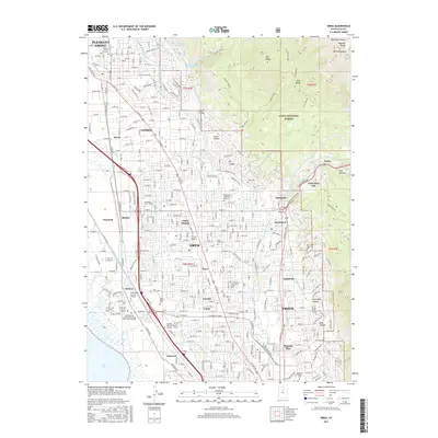
2017 Map of Orem
USGS Topo · Published 2017About this map
Orem and its neighboring communities sit at the foot of the Wasatch Range, where the suburban landscape meets the steep peaks of Mt Timpanogos. This 2017 study illustrates the dense development of the Provo Bench, a terrace between the mountains and the eastern shore of Utah Lake. The region’s reliance on water infrastructure is evident in the complex network of the Murdock Canal, Jordan Aqueduct, and Salt Lake City Aqueduct crossing the valley floor. Educational institutions serve as major anchors for the area, including Utah Valley University and the northern edge of the Brigham Young University campus. While much of the area is urbanized, the eastern margin transitions abruptly into the Uinta National Forest, where deep incisions like Rock Canyon and Dry Canyon separate the heights of Big Baldy and Little Baldy.
Find a feature on this map
71 named features on this map. Tap any name to fly to it.
Don’t see what you’re looking for? This feature index may not catch every label — zoom into the map to look around manually.
Map Details
Editions of this 2017 Orem Map
This is the sole edition of this map. No revisions or reprints were ever made.
Other maps of this area

1885 · Salt Lake
USGS Topo · 1:250,000

1948 · Timpanogos Cave
USGS Topo · 1:24,000

1948 · Orem
USGS Topo · 1:24,000

1948 · Orem
USGS Topo · 1:62,500

1948 · Springville
USGS Topo · 1:24,000

1948 · Aspen Grove
USGS Topo · 1:24,000

1948 · Provo
USGS Topo · 1:24,000

1948 · Bridal Veil Falls
USGS Topo · 1:24,000

1949 · Provo
USGS Topo · 1:62,500

1950 · Orem
USGS Topo · 1:24,000