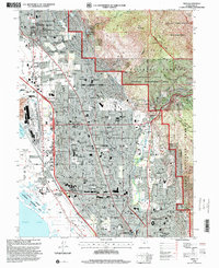
1998 Map of Orem
USGS Topo · Published 2000About this map
Mount Timpanogos towers over the eastern edge of this late-twentieth-century landscape, where the rising peaks of the Uinta National Forest meet the expanding residential corridors of Orem and Pleasant Grove. The map details a period of significant institutional and educational growth, featuring the Utah Valley State College (Orem Campus) and the northern reaches of Brigham Young University, complete with Cougar Stadium. Along the Union Pacific rail line, industrial and agricultural legacies remain visible through features like the Bunker Grain Elevators and various gravel pits. The transition from the wetlands of Powell Slough at the edge of Utah Lake to the high-elevation Wilderness areas near Big Provo Cirque illustrates the diverse terrain that dictated the development patterns of these Utah Valley communities.
Find a feature on this map
101 named features on this map. Tap any name to fly to it.
Don’t see what you’re looking for? This feature index may not catch every label — zoom into the map to look around manually.
Map Details
Editions of this 1998 Orem Map
This is the sole edition of this map. No revisions or reprints were ever made.
Other maps of this area

1885 · Salt Lake
USGS Topo · 1:250,000

1948 · Timpanogos Cave
USGS Topo · 1:24,000

1948 · Orem
USGS Topo · 1:24,000

1948 · Orem
USGS Topo · 1:62,500

1948 · Springville
USGS Topo · 1:24,000

1948 · Aspen Grove
USGS Topo · 1:24,000

1948 · Provo
USGS Topo · 1:24,000

1948 · Bridal Veil Falls
USGS Topo · 1:24,000

1949 · Provo
USGS Topo · 1:62,500

1950 · Orem
USGS Topo · 1:24,000