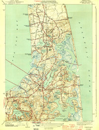
1944 Map of Orleans
USGS Topo · Published 1944About this map
Lower Cape Cod’s intricate transition from the tranquil waters of Cape Cod Bay to the exposed Atlantic Ocean shoreline is captured here during the 1940s. The landscape is defined by the narrow waist of the peninsula at Town Cove, where the New York New Haven and Hartford railroad cuts through the heart of Orleans and North Eastham. This era precedes the major post-war development of the National Seashore, showing a more local network of roads like Cable Road and Barley Neck Road serving established coastal settlements and isolated shorefronts.
Find a feature on this map
87 named features on this map. Tap any name to fly to it.
Don’t see what you’re looking for? This feature index may not catch every label — zoom into the map to look around manually.
Map Details
Editions of this 1944 Orleans Map
3 editions found

Other maps of this area

1887 · Wellfleet
USGS Topo · 1:62,500

1887 · Yarmouth
USGS Topo · 1:62,500

1888 · Chatham
USGS Topo · 1:62,500

1889 · Yarmouth
USGS Topo · 1:62,500

1889 · Wellfleet
USGS Topo · 1:62,500

1893 · Chatham
USGS Topo · 1:62,500

1893 · Yarmouth
USGS Topo · 1:62,500

1893 · Wellfleet
USGS Topo · 1:62,500

1917 · Chatham
USGS Topo · 1:62,500

1942 · Cape Cod Bay
USGS Topo · 1:125,000