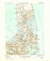
1944 Map of Orleans
USGS Topo · Published 1947About this map
Town Cove and the narrow interior waterways of the mid-Cape define the landscape of this 1940s-era survey, showing the transition from agricultural coastal settlements to established maritime communities. The rail corridor of the New York New Haven and Hartford cuts through the center of Orleans, linking it to Eastham and North Eastham. This infrastructure, combined with the presence of Nauset C G Sta and Orleans C G Sta, underscores the area's strategic coastal significance during the mid-20th century.
Find a feature on this map
88 named features on this map. Tap any name to fly to it.
Don’t see what you’re looking for? This feature index may not catch every label — zoom into the map to look around manually.
Map Details
Editions of this 1944 Orleans Map
3 editions found

Other maps of this area

1887 · Wellfleet
USGS Topo · 1:62,500

1887 · Yarmouth
USGS Topo · 1:62,500

1888 · Chatham
USGS Topo · 1:62,500

1889 · Yarmouth
USGS Topo · 1:62,500

1889 · Wellfleet
USGS Topo · 1:62,500

1893 · Chatham
USGS Topo · 1:62,500

1893 · Yarmouth
USGS Topo · 1:62,500

1893 · Wellfleet
USGS Topo · 1:62,500

1917 · Chatham
USGS Topo · 1:62,500

1942 · Cape Cod Bay
USGS Topo · 1:125,000