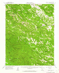
1960 Map of Ornbaun Valley
USGS Topo · Published 1962About this map
Ornbaun Valley and the Anderson Valley serve as focal points for this remote landscape, where Mendocino and Sonoma counties meet. In the early 1960s, the terrain was defined by a series of prominent ridges, including German Ridge, Phelps Ridge, and Rockpile Ridge, which channeled the many forks of the Gualala River and Garcia River. The map reveals a land utilized for both recreation and large-scale ranching, featuring the Mailliard Ranch and the Helvetian Gun Club. A network of specialized openings, such as the Little Horse Opening and Mule Opening, suggests a history of livestock management or forest clearing. Notable landmarks for local researchers include the Ornbaun Sprs Cem and the Gualala Mtn Lookout, alongside the preserved groves of Mailliard Redwoods State Park.
Find a feature on this map
92 named features on this map. Tap any name to fly to it.
Don’t see what you’re looking for? This feature index may not catch every label — zoom into the map to look around manually.
Map Details
Editions of this 1960 Ornbaun Valley Map
2 editions found
Other maps of this area

1920 · Ukiah
USGS Topo · 1:62,500

1921 · Skaggs
USGS Topo · 1:62,500

1921 · Plantation
USGS Topo · 1:62,500

1938 · Hopland
USGS Topo · 1:62,500

1943 · Point Arena
USGS Topo · 1:62,500

1943 · Tombs Creek
USGS Topo · 1:24,000

1943 · Boonville
USGS Topo · 1:62,500

1943 · Navarro
USGS Topo · 1:62,500

1943 · Stewarts Point
USGS Topo · 1:24,000

1943 · Annapolis
USGS Topo · 1:24,000