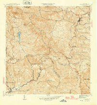
1946 Map of Orocovis
USGS Topo · Published 1946About this map
Orocovis sits at the heart of the Cordillera Central mountains during the mid-1940s, a period when the interior of Puerto Rico was defined by coffee production and high-altitude settlements. The map details the intricate drainage basins of the Rio Bauta and Rio Orocovis, alongside landmarks like Lago de Matrullas. Social and economic structures of the era are visible through labels for the Escuela Segunda Unidad de Bauta and Hacienda Limon, reflecting the rural educational reforms and agricultural estates of the time. The terrain is dominated by prominent peaks such as Cerro Mime and Cerro El Malo, while the Linea Transmision indicates early modernization efforts reaching into the mountainous barrios of Barros, Collores, and Pellejas.
Find a feature on this map
62 named features on this map. Tap any name to fly to it.
Don’t see what you’re looking for? This feature index may not catch every label — zoom into the map to look around manually.
Map Details
Editions of this 1946 Orocovis Map
3 editions found
Other maps of this area

1945 · Ponce
USGS Topo · 1:30,000

1945 · Rio Descalabrado
USGS Topo · 1:30,000

1946 · Coamo
USGS Topo · 1:30,000

1946 · Corozal
USGS Topo · 1:30,000

1946 · Barranquitas
USGS Topo · 1:30,000

1946 · Ciales
USGS Topo · 1:30,000

1946 · Jayuya
USGS Topo · 1:30,000

1946 · Florida
USGS Topo · 1:30,000

1946 · Orocovis
USGS Topo · 1:30,000

1947 · Corozal SO
USGS Topo · 1:10,000