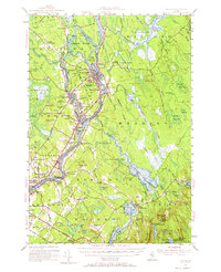
1955 Map of Orono
USGS Topo · Published 1965About this map
The Penobscot River defines the industrial and educational heart of this mid-century landscape, anchoring the bustling communities of Old Town, Milford, and Orono. The river's path is marked by substantial islands such as Indian Island and Orson Island, while the Maine Central Railroad parallels the eastern bank, tracing the established corridors of Maine's timber and milling economy. The sprawling campus of the University of Maine is shown in detail, surrounded by extensive research lands like the University of Maine Forest.
Find a feature on this map
103 named features on this map. Tap any name to fly to it.
Don’t see what you’re looking for? This feature index may not catch every label — zoom into the map to look around manually.
Map Details
Editions of this 1955 Orono Map
4 editions found
Other maps of this area

1900 · Orland
USGS Topo · 1:62,500

1900 · Bucksport
USGS Topo · 1:62,500

1902 · Orono
USGS Topo · 1:62,500

1902 · Bucksport
USGS Topo · 1:62,500

1902 · Bangor
USGS Topo · 1:62,500

1911 · Ellsworth
USGS Topo · 1:62,500

1917 · Passadumkeag
USGS Topo · 1:62,500

1929 · Great Pond
USGS Topo · 1:48,000

1931 · Saponac
USGS Topo · 1:48,000

1932 · Great Pond
USGS Topo · 1:62,500