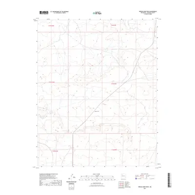
2023 Map of Orphan Annie Rock
USGS Topo · Published 2023About this map
Inditos Draw carves a path through the high desert landscape of McKinley County, illustrating the natural drainage patterns of this arid New Mexico region. This modern topographic study, based on data from the U.S. Geological Survey and imagery from 2020, captures the subtle variations in elevation across the western plateau. The map is defined by its Public Land Survey System divisions, including t17n r9w and t17n r10w, which reflect the historical grid-based land management of the American West. The lack of named settlements or major infrastructure highlights the open, expansive nature of the terrain, where natural watercourses like the draw remain the most prominent geographic landmarks for navigation and land study.
Find a feature on this map
7 named features on this map. Tap any name to fly to it.
Don’t see what you’re looking for? This feature index may not catch every label — zoom into the map to look around manually.
Map Details
Editions of this 2023 Orphan Annie Rock Map
This is the sole edition of this map. No revisions or reprints were ever made.
Other maps of this area

1883 · Mt. Taylor
USGS Topo · 1:250,000

1886 · Mt. Taylor
USGS Topo · 1:250,000

1892 · Mt. Taylor
USGS Topo · 1:250,000

1899 · Mt. Taylor
USGS Topo · 1:250,000

1958 · Albuquerque
USGS Topo · 1:250,000

1961 · Piedra De La Aguila
USGS Topo · 1:24,000

1961 · Whitehorse
USGS Topo · 1:24,000

1961 · Hospah
USGS Topo · 1:24,000

1962 · Albuquerque
USGS Topo · 1:250,000
1963 · Laguna Castillo
USGS Topo · 1:24,000