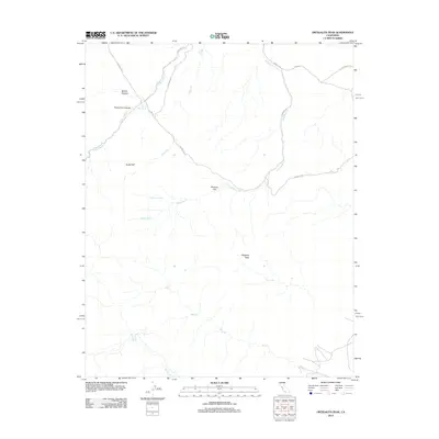
2012 Map of Ortigalita Peak
USGS Topo · Published 2012About this map
Ortigalita Peak anchors this corner of Fresno County, overlooking a landscape defined by seasonal drainages and remote ranch roads in the early 21st century. The terrain is marked by a complex network of canyons and flats, including Molina Canyon and Wisenor Flat, where the presence of water sources like Piedra Azul Spring and Carranza Spring would have been vital for livestock and early inhabitants. These springs and the numerous ephemeral streams, such as Miner Cr and Ortigalita Cr, dictate the movement of roads through the foothills. Local transport relies on a web of named routes like Arburua Rd and Langdon Rd that trace the contours of the land, connecting isolated high points like the distinctive Sugarloaf with the lower creek beds.
Find a feature on this map
19 named features on this map. Tap any name to fly to it.
Don’t see what you’re looking for? This feature index may not catch every label — zoom into the map to look around manually.
Map Details
Editions of this 2012 Ortigalita Peak Map
This is the sole edition of this map. No revisions or reprints were ever made.
Other maps of this area

1913 · Panoche
USGS Topo · 1:125,000

1919 · San Benito
USGS Topo · 1:62,500

1920 · Carrisalito Spring
USGS Topo · 1:31,680

1921 · Laguna Seca Ranch
USGS Topo · 1:31,680

1922 · Charleston School
USGS Topo · 1:31,680

1922 · Quien Sabe
USGS Topo · 1:62,500

1922 · Ortigalita
USGS Topo · 1:31,680

1923 · Laguna Seca Ranch
USGS Topo · 1:31,680

1931 · San Benito
USGS Topo · 1:62,500

1940 · Quien Sabe
USGS Topo · 1:62,500