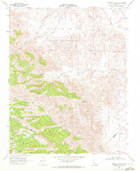
1969 Map of Ortigalita Peak
USGS Topo · Published 1972About this map
Ortigalita Ridge dominates the center of this 1960s topographical study, marking a high divide where the boundaries of Merced and San Benito counties meet. This terrain is characterized by a network of seasonal drainages and numerous water sources essential for cattle ranching, including Piedra Azul Spring, Carranza Spring, and several unnamed springs scattered across Wisenor Flat. Evidence of small-scale resource extraction appears in the form of a Mine and various Prospect sites located south of Ortigalita Peak. The map illustrates a complex landscape of private landholdings, indicated by fine red dashed lines representing fence lines, and the primitive transportation network of the era, consisting primarily of a Jeep Trail winding through Piedra Azul Canyon and Molina Canyon. In the southeast, Little Panoche Creek cuts through the valley floor at the Merced and Fresno county line.
Find a feature on this map
21 named features on this map. Tap any name to fly to it.
Don’t see what you’re looking for? This feature index may not catch every label — zoom into the map to look around manually.
Map Details
Editions of this 1969 Ortigalita Peak Map
2 editions found
Other maps of this area

1913 · Panoche
USGS Topo · 1:125,000

1919 · San Benito
USGS Topo · 1:62,500

1920 · Carrisalito Spring
USGS Topo · 1:31,680

1921 · Laguna Seca Ranch
USGS Topo · 1:31,680

1922 · Charleston School
USGS Topo · 1:31,680

1922 · Quien Sabe
USGS Topo · 1:62,500

1922 · Ortigalita
USGS Topo · 1:31,680

1923 · Laguna Seca Ranch
USGS Topo · 1:31,680

1931 · San Benito
USGS Topo · 1:62,500

1940 · Quien Sabe
USGS Topo · 1:62,500