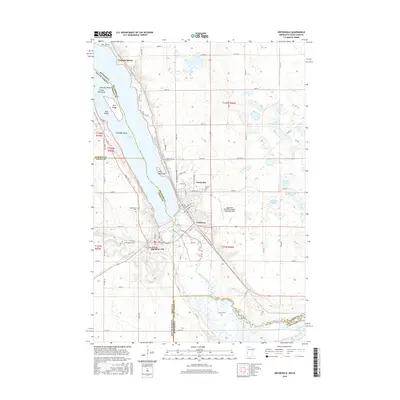
2016 Map of Ortonville
USGS Topo · Published 2016About this map
Ortonville and Big Stone City sit at the strategic southern terminus of Big Stone Lake, where the Whetstone River and Minnesota River converge at the state border. This 2016 survey highlights the intricate hydrology of the region, including smaller bodies of water like Walter Lake, Lindgren Lake, and Deep Lake. The landscape is defined by the narrow, glacial lake valley and the surrounding high ground where settlements like Cashtown and Lagoona Beach have developed. Genealogists and local historians will find several burial grounds documented, including Mound Cem and Greenwood Cem. Notable geographic landmarks such as The Peninsula and a series of uniquely named islands, including Pancake Island and Skeleton Island, provide a detailed look at the lake's shoreline morphology as it existed in the mid-2010s.
Find a feature on this map
70 named features on this map. Tap any name to fly to it.
Don’t see what you’re looking for? This feature index may not catch every label — zoom into the map to look around manually.
Map Details
Editions of this 2016 Ortonville Map
This is the sole edition of this map. No revisions or reprints were ever made.
Other maps of this area

1953 · Ortonville
USGS Topo · 1:62,500

1953 · Bellingham
USGS Topo · 1:62,500

1953 · Milbank
USGS Topo · 1:250,000

1954 · Big Stone Lake
USGS Topo · 1:62,500

1958 · Milbank
USGS Topo · 1:250,000

1971 · Big Stone Lake East
USGS Topo · 1:24,000

1971 · Dismal Swamp
USGS Topo · 1:24,000

1971 · Odessa
USGS Topo · 1:24,000
1971 · Bellingham
USGS Topo · 1:24,000

1971 · Rosen
USGS Topo · 1:24,000