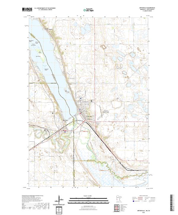
2022 Map of Ortonville
USGS Topo · Published 2022About this map
Ortonville and Big Stone City anchor the southern tip of Big Stone Lake, where the state line divides Minnesota and South Dakota. This modern survey illustrates a landscape deeply shaped by the shoreline, with neighborhoods like Lagoona Beach and The Peninsula extending into the water. Significant local infrastructure is clearly visible, including the Big Stone County Courthouse and the Ortonville Municipal Airport-Martinson Field.
Find a feature on this map
103 named features on this map. Tap any name to fly to it.
Don’t see what you’re looking for? This feature index may not catch every label — zoom into the map to look around manually.
Map Details
Editions of this 2022 Ortonville Map
This is the sole edition of this map. No revisions or reprints were ever made.
Other maps of this area

1953 · Ortonville
USGS Topo · 1:62,500

1953 · Bellingham
USGS Topo · 1:62,500

1953 · Milbank
USGS Topo · 1:250,000

1954 · Big Stone Lake
USGS Topo · 1:62,500

1958 · Milbank
USGS Topo · 1:250,000

1971 · Big Stone Lake East
USGS Topo · 1:24,000

1971 · Dismal Swamp
USGS Topo · 1:24,000

1971 · Odessa
USGS Topo · 1:24,000
1971 · Bellingham
USGS Topo · 1:24,000

1971 · Rosen
USGS Topo · 1:24,000