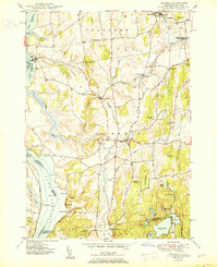
1927 Map of Orwell
USGS Topo · Published 1927About this map
The eastern shores of Lake Champlain define this 1950 edition, where the maritime and agricultural landscapes of Addison County meet the Rutland Railroad. The village of Orwell sits centrally, supported by surrounding hamlets like North Orwell and the landing at Larrabees Point. Transport patterns of the mid-20th century are evident in the rail line connecting Hough Crossing and Shoreham Center, while the interior is dotted with rural education and social centers such as Hough Crossing School and Barnum Hill School.
Find a feature on this map
66 named features on this map. Tap any name to fly to it.
Don’t see what you’re looking for? This feature index may not catch every label — zoom into the map to look around manually.
Map Details
Editions of this 1927 Orwell Map
This is the sole edition of this map. No revisions or reprints were ever made.
Other maps of this area

1893 · Whitehall
USGS Topo · 1:62,500

1894 · Ticonderoga
USGS Topo · 1:62,500

1895 · Whitehall
USGS Topo · 1:62,500

1895 · Castleton
USGS Topo · 1:62,500

1896 · Ticonderoga
USGS Topo · 1:62,500

1897 · Castleton
USGS Topo · 1:62,500

1898 · Whitehall
USGS Topo · 1:62,500

1902 · Whitehall
USGS Topo · 1:62,500

1902 · Ticonderoga
USGS Topo · 1:62,500

1902 · Brandon
USGS Topo · 1:62,500