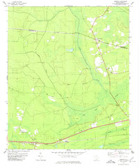
1979 Map of Osborn
USGS Topo · Published 1980About this map
Caw Caw Swamp and the dense wetlands of the Lowcountry dominate this landscape, which is marked by a complex network of historical creek crossings and rural junctions. At Delemar Crossroads and Warren Crossroads, the map illustrates a settlement pattern typical of this coastal plain region, where small communities anchored by St Pauls Ch and White Cem emerged along old transport routes. To the south, the Seaboard Coast Line railroad runs parallel to the highway, connecting the town of Osborn with nearby Jericho. The presence of Parkers Ferry Road indicates the enduring path of an earlier river crossing, while the surrounding Drayton Swamp and Caddin Bridge Swamp speak to the challenging terrain that shaped early road and rail placement. Local history is well-represented through numerous church and cemetery sites, including Mt Nebo Ch and the Stono Ch Cem.
Find a feature on this map
26 named features on this map. Tap any name to fly to it.
Don’t see what you’re looking for? This feature index may not catch every label — zoom into the map to look around manually.
Map Details
Editions of this 1979 Osborn Map
This is the sole edition of this map. No revisions or reprints were ever made.
Other maps of this area

1918 · Cottageville
USGS Topo · 1:62,500

1919 · Edisto Island
USGS Topo · 1:62,500

1919 · Wadmelaw Island
USGS Topo · 1:62,500

1920 · Ravenels
USGS Topo · 1:62,500

1943 · Cottageville
USGS Topo · 1:62,500

1943 · Edisto Island
USGS Topo · 1:62,500

1944 · Ravenels
USGS Topo · 1:62,500

1944 · Wadmelaw Island
USGS Topo · 1:62,500

1947 · Savannah
USGS Topo · 1:250,000

1948 · Savannah
USGS Topo · 1:250,000