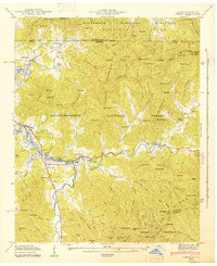
1943 Map of Osborn
USGS Topo · Published 1943About this map
The Chatuge Reservoir dominates the western landscape of this 1943 survey, showing the shoreline as it was newly established during the early 1940s. Along the banks and tucked into the surrounding ridges of the Chattahoochee National Forest and Nantahala National Forest, a network of mountain communities remains visible. Settlements like Osborn, Macedonia, and Presley are anchored by local institutions, including Macedonia Ch and Lower Hightower Sch. The map provides a detailed view of the Hiwassee River valley before further modern development, capturing the location of many family-named landmarks and cemeteries such as Garrett Cem and Ivy Mount Cem. For those tracing the historical geography of the Georgia-North Carolina border, the map highlights the rugged topography from Eagle Mountain to the high points at Shooting Creek Bald, while the Appalachian Trail winds through the southern gaps.
Find a feature on this map
142 named features on this map. Tap any name to fly to it.
Don’t see what you’re looking for? This feature index may not catch every label — zoom into the map to look around manually.
Map Details
Editions of this 1943 Osborn Map
This is the sole edition of this map. No revisions or reprints were ever made.
Other maps of this area

1886 · Dahlonega
USGS Topo · 1:125,000

1892 · Dahlonega
USGS Topo · 1:125,000

1896 · Dahlonega
USGS Topo · 1:125,000

1903 · Dahlonega
USGS Topo · 1:125,000

1935 · Osborn
USGS Topo · 1:24,000

1935 · Rainbow Springs
USGS Topo · 1:24,000

1935 · Shooting Creek
USGS Topo · 1:24,000

1935 · Wayah Bald
USGS Topo · 1:48,000

1935 · Hightower Bald
USGS Topo · 1:24,000

1935 · Tray Mountain
USGS Topo · 1:24,000