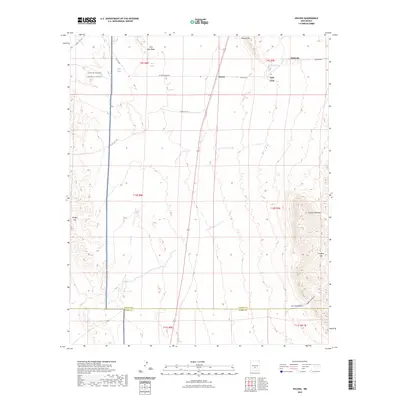
2023 Map of Oscura
USGS Topo · Published 2023About this map
White Sands Missile Range dominates the western portion of this High Desert landscape, where the modern military footprint meets the remnants of older ranching and transportation networks. The settlement of Oscura and nearby Cora sit along the north-south transit corridor, while the higher elevations of Bull Gap Ridge and Milagro Hill break the basin floor. Water sources are critical in this arid environment, evidenced by scattered points like Milagro Springs, Keen Spring, and Phillips Springs. The topography transitions from the flat plains in the west to the more complex relief of the Godfrey Hills and Jackass Mountain in the southeast, where Lopez Canyon carves through the terrain. County boundaries divide the southern reach, separating Lincoln and Otero counties near New Well Draw.
Find a feature on this map
29 named features on this map. Tap any name to fly to it.
Don’t see what you’re looking for? This feature index may not catch every label — zoom into the map to look around manually.
Map Details
Editions of this 2023 Oscura Map
This is the sole edition of this map. No revisions or reprints were ever made.
Other maps of this area

1916 · Tularosa
USGS Topo · 1:125,000

1918 · Oscura Peak
USGS Topo · 1:125,000

1938 · Carrizozo
USGS Topo · 1:48,000

1943 · Carrizozo
USGS Topo · 1:62,500

1947 · Three Rivers
USGS Topo · 1:62,500

1948 · Chihuahua Ranch
USGS Topo · 1:62,500

1950 · Three Rivers
USGS Topo · 1:24,000

1950 · Oscura
USGS Topo · 1:24,000

1950 · Carrizozo
USGS Topo · 1:62,500

1950 · Sierra Blanca Peak
USGS Topo · 1:62,500