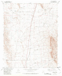
1981 Map of Oscura
USGS Topo · Published 1982About this map
Southern Pacific tracks cut through the high desert of the Tularosa Basin here, anchoring the small settlement of Oscura. The landscape is defined by the logistics of ranching and military operations, as the western portion of the sheet falls within the White Sands Missile Range. Water sources are the critical lifeblood of this arid environment, marked by numerous cattle-related features like the Taylor Windmill, Jackson Well, and Milagro Springs. Rising above the basin floor are the Phillips Hills and Bull Gap Ridge, while the Godfrey Hills dominate the eastern topography. The map also records early-stage mining interests with several Prospect and Mine notations near Milagro Hill, reflecting the intersection of the railroad economy and desert resource extraction in the early 1980s.
Find a feature on this map
30 named features on this map. Tap any name to fly to it.
Don’t see what you’re looking for? This feature index may not catch every label — zoom into the map to look around manually.
Map Details
Editions of this 1981 Oscura Map
This is the sole edition of this map. No revisions or reprints were ever made.
Other maps of this area

1916 · Tularosa
USGS Topo · 1:125,000

1918 · Oscura Peak
USGS Topo · 1:125,000

1938 · Carrizozo
USGS Topo · 1:48,000

1943 · Carrizozo
USGS Topo · 1:62,500

1947 · Three Rivers
USGS Topo · 1:62,500

1948 · Chihuahua Ranch
USGS Topo · 1:62,500

1950 · Three Rivers
USGS Topo · 1:24,000

1950 · Oscura
USGS Topo · 1:24,000

1950 · Carrizozo
USGS Topo · 1:62,500

1950 · Sierra Blanca Peak
USGS Topo · 1:62,500