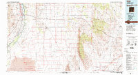
1982 Map of Oscura Mountains
USGS Topo · Published 1983About this map
White Sands Missile Range dominates the central and eastern portions of this High Desert landscape, marking a significant 1980s military footprint across the Tularosa Basin. The map identifies the Trinity Site (Historic) northwest of the Oscura Mountains, where the world's first nuclear test occurred decades prior. To the west, the Rio Grande valley provides a stark contrast to the arid interior, supporting the lush wetlands of the Bosque del Apache National Wildlife Refuge.
Find a feature on this map
55 named features on this map. Tap any name to fly to it.
Don’t see what you’re looking for? This feature index may not catch every label — zoom into the map to look around manually.
Map Details
Editions of this 1982 Oscura Mountains Map
This is the sole edition of this map. No revisions or reprints were ever made.
Other maps of this area

1906 · Socorro
USGS Topo · 1:62,500

1916 · La Joya
USGS Topo · 1:125,000

1916 · Salinas Peak
USGS Topo · 1:125,000

1916 · Tularosa
USGS Topo · 1:125,000

1918 · Oscura Peak
USGS Topo · 1:125,000

1938 · Carrizozo
USGS Topo · 1:48,000

1943 · Carrizozo
USGS Topo · 1:62,500

1947 · Three Rivers
USGS Topo · 1:62,500

1947 · Capitol Peak
USGS Topo · 1:62,500

1948 · Carthage
USGS Topo · 1:62,500