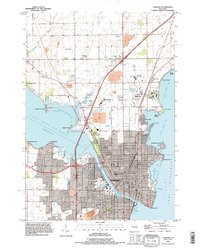
1992 Map of Oshkosh
USGS Topo · Published 1996About this map
The Fox River cuts through the heart of Oshkosh, serving as the central artery between Lake Butte des Morts and Lake Winnebago. This 1990s revision reveals a landscape heavily shaped by public and institutional land use, with the Winnebago State Hospital complex and the Winnebago State Prison Farm occupying significant tracts along North Asylum Bay. The city's academic and civic core is anchored by the University of Wisconsin Oshkosh and an extensive grid of streets extending south of Murdock Ave.
Find a feature on this map
75 named features on this map. Tap any name to fly to it.
Don’t see what you’re looking for? This feature index may not catch every label — zoom into the map to look around manually.
Map Details
Editions of this 1992 Oshkosh Map
This is the sole edition of this map. No revisions or reprints were ever made.
Other maps of this area

1910 · Fond du Lac
USGS Topo · 1:62,500

1911 · Neenah
USGS Topo · 1:62,500

1955 · Neenah
USGS Topo · 1:62,500

1955 · Neenah
USGS Topo · 1:24,000

1955 · Fond Du Lac
USGS Topo · 1:62,500

1955 · Green Bay
USGS Topo · 1:250,000

1956 · Rosendale
USGS Topo · 1:62,500

1957 · Madison
USGS Topo · 1:250,000

1960 · Madison
USGS Topo · 1:250,000

1961 · Oshkosh
USGS Topo · 1:24,000