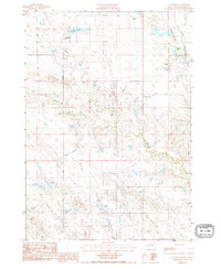
1983 Map of Ottumwa
USGS Topo · Published 1984About this map
The settlement of Ottumwa anchor this high plains landscape in Haakon County, situated near the banks of Ottumwa Lake. This 1980s-era survey documents a region defined by its ranching heritage, with prominent family-named holdings distributed across the terrain, including Schofield Ranch, Heeb Ranch, and Hostutler Ranch. A complex network of drainage systems such as Mule Creek, Mitchell Creek, and Jack Dailey Creek carves through the landscape, illustrating the importance of water access for livestock in this environment. The presence of the Armstrong Landing Strip near the Armstrong Ranch highlights the necessity of private aviation for transport and land management in these remote western stretches of South Dakota. Local travel is facilitated by the Ottumwa Road, which connects the small community to the surrounding rural ranchlands.
Find a feature on this map
19 named features on this map. Tap any name to fly to it.
Don’t see what you’re looking for? This feature index may not catch every label — zoom into the map to look around manually.
Map Details
Editions of this 1983 Ottumwa Map
This is the sole edition of this map. No revisions or reprints were ever made.
Other maps of this area

1954 · Powell
USGS Topo · 1:24,000

1954 · Midland
USGS Topo · 1:24,000

1954 · Nowlin
USGS Topo · 1:24,000

1954 · Pierre
USGS Topo · 1:250,000

1958 · Pierre
USGS Topo · 1:250,000

1982 · Midland NW
USGS Topo · 1:24,000

1982 · May Ranch
USGS Topo · 1:24,000

1983 · Mule Creek
USGS Topo · 1:24,000

1983 · Philip
USGS Topo · 1:100,000

1983 · Powell NW
USGS Topo · 1:24,000